
Course Info
Our course will celebrate the peaks and foothills of the Appalachian Mountains. The course is hilly, both up and down. The race will begin in Asheville, NC, and travel through Hendersonville, NC, and Travelers Rest, SC, with stops at Southern Appalachian Brewery and Swamp Rabbit Brewery. Over the course of the day, there are 11 transitions, where one of your teammates ends their run and another begins. Teams will finish at Hampton Station with a celebration featuring local brewers, music, and food trucks. Our course routes and our trusty guidebook will help you navigate the day. Please remember that this is an open-road course, so each team will need to take additional safety precautions.
Required Safety Equipment for Each Team
Two Reflective Vests | Two Headlamps | Two Blinking LED Lights
2027 Course Info TBA - 2026 Course Legs & Ratings Below
Leg #1 - AC Reynolds Middle School to Skyland Fire Department - 6.00 Miles - Rating = Very Hard
Leg #2 - Skyland Fire Department to Souther Williams Vineyard - 5.84 Miles - Rating = Hard
Leg #3 - Souther Williams Vineyard to Fletcher Elementary School - 6.45 Miles - Rating = Hard
Leg #4 - Fletcher Elementary School to Southern Appalachian Brewery - 7.90 Miles - Rating = Very Hard
Leg #5 - Southern Appalachian Brewery to Hillandale Elementary School - 5.45 Miles - Rating = Moderate
Leg #6 - Hillandale Elementary School to Tuxedo Park - 4.64 Miles - Rating = Moderate
Leg #7 - Tuxedo Park to Talisman Programs - 3.53 Miles - Rating = Moderate
Leg #8 - Talisman Programs to Hotel Domestique - 8.81 Miles - Rating = Hard
Leg #9 - Hotel Domestique to Foothills Family Resources - 8.83 Miles - Rating = Very Hard
Leg #10 - Foothills Family Resources to Swamp Rabbit Brewery - 6.71 Miles - Rating = Hard
Leg #11 - Swamp Rabbit Brewery to Enoree Career Center - 4.44 Miles - Rating = Easy
Leg #12 - Enoree Career Center to Hampton Station - 3.94 Miles - Rating = Easy
Full Course - 72.6 Miles
NEW FOR 2026 - Strava Maps for each leg are now available and can be downloaded to your watch or device and used for directions if you have a subscription.
Course Resources
Course Leg Ratings and Rankings
Runner Directions - Printable
Pace Calculator - Click "Make a copy" to help calculate your team's pace.
Timing Adjustment Form - Use to report any on-course delays during the relay.
Driving Directions - With Google Maps
Driving Directions - Printable
Directional Tips
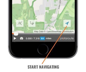
If you have a smartphone with GPS capabilities, you can use the plotaroute app to help follow a route from plotaroute.com.
1. Select the route you want to follow and view the interactive route map.
2. Tap on the Tracker icon in the bottom right to enter SatNav mode.
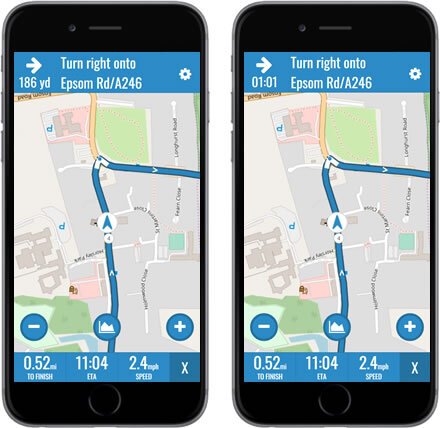
3. Follow the route using the tracker marker as a guide. The app will automatically detect your position on the route from your current location and heading. The next turn will be shown at the top of the screen, along with the distance to the turn. Tapping the Distance To Turn will toggle it to show time instead of distance.
4. To display the route's hill profile tap on the Hills button. Your hill position will be indicated by a blue dot.
5. You can zoom in and out by tapping on the + and - buttons on the map.
6. There are 3 data fields at the bottom of the screen:
- DISTANCE TO END OF ROUTE - Tap this to change between miles and km.
- ETA / TIME TO FINISH - Tap this to toggle between ETA and Time Remaining.
- SPEED / ELEVATION - Tap this to change between current speed and current height above sea level.\
7. To access the SatNav settings, tap the gear icon in the top right.
8. The following Navigation settings are available.
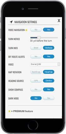
VOICE NAVIGATION (Premium feature)
- VOICE NAVIGATION - Enable/disable voice navigation.
- TURN NOTICE - How far before each turn you want a voice alert.
- TURN INFO:
- BRIEF - Turn direction only, e.g. Turn left
- VERBOSE - Reads the directions (max. 25 words), e.g. Turn left onto Sunshine Avenue
- OFF-ROUTE ALERTS - Alerts you when you are off-route, including heading in the wrong direction.
- VOICE - The voice that will be used to speak the navigation instructions (see note below).
- OTHER SETTINGS
- MAP ROTATION - North Up (no rotation) or Head Up (rotate map for current heading).
- HEADING SOURCE - GPS (heading changes when you move) or DEVICE (heading changes when you rotate your device).
- SHOW COMPASS - Display a compass on the map.
- DARK MODE - Uses a dark maps during navigation to conserve battery life.
9. To exit SatNav mode tap the X in the bottom right corner.