
Events
Description
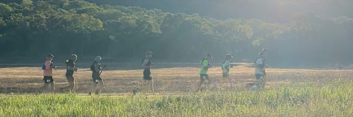
Experience the beauty of Cookson Hills Wildlife Management Area (WMA). There is a 70 participant cap on the event based on our permit. We must all do our part in keeping Cookson free of litter as always: Leave No Trace. If we want a shot at being allowed to hold future events in Cookson, we must protect the land and the animals who call it home.
7am Packet Pickup
8am Run/Hike/Walk Start
7pm Cutoff
Buckles, Awards, Eats
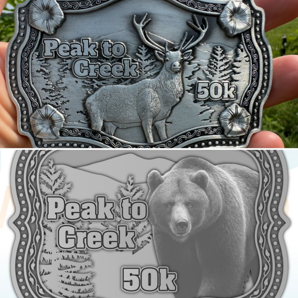
Those who complete the 33 mile loop within the 11-hour (7pm) Cutoff receive a finisher belt buckle.
Buckle theming is based on animals that live in the refuge. We have 19 elk buckles and 51 bear buckles. Finishers pick which buckle they prefer as they finish.
Top 3 finishers receive awards. No gender awards. Top 3 humans.
This is not a chip timed event due to it being a single 33-mile continuous loop with only 70 participants. However, we will be recording finish times just as diligently as we would with any chip timed event.
We're having chili at the finish. So bring a chair and join us for food and fellowship.
Swag
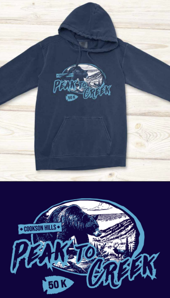
All participants receive a hoodie. 80% cotton, 20% polyester. You’re welcome to order an Additional Hoodie if you would like an extra for family, friends, or crew. Hoodie orders will be collected through Monday 1/19/2026. If you want a guaranteed hoodie with your run registration, please sign up before then. Shoutout to Travis at M&S Screenprinting for putting together the design for us. If you need shirts or hats, then give Dea, Emma, Tara, and the team a holler.
Update: Race sold out early December. Hoodie order already placed.
Course
This 33 mile adventure follows dirt/gravel roads and four-wheel drive access roads that can often be covered with thick leaves in sections. There is about 4,500' of elevation. Trekking poles are allowed. There are multiple water crossings. It may be dry creek beds or it may be knee deep depending on rainfall. As the race has changed from hot to cold season, there could also be snow and ice. Most of the time you will not be able to see people in front or behind you. The course will be marked, but it is your responsibility to know the route. It is highly recommended that you use an app that sends live tracking data back to race staff and your emergency contact person. Watch Race Director Isaac Barnoskie’s video on how to use the Strava beacon feature to do this: https://www.facebook.com/share/r/DkPiEYnBp1VuLmBk/?Course is not closed to vehicle traffic, but it is rare for vehicles to be in the area, as it is remote and some of it requires 4-wheel drive for passage. The only ATV's allowed on the course are those used by race staff to sweep the course and provide first aid or extraction if necessary.
Download GPX File from Google Drive

Elevation Profile

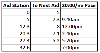
Aid Stations, Water, and Pace Chart
Most intersections have road signs. There will be event signs telling you which way to go, and current location on the map. The Aid column is distance from start. Corresponding symbol on the map is the cookie. Next Aid is distance from current aid station to the next aid station. Aid stations will have hydration and calories. First aid kits are at each aid station. Be prepared to administer your own first aid and tend to your own feet. With an 11 hour cutoff across 33 miles, you need a 20:00/mi pace. You need to be moving out of the aid station by the times in the 20:00/mi Pace column. An aid station captain may not allow you to continue if they deem it unsafe for you to continue. Take care of yourself.
There is a porta potty at the start/finish. If using the bathroom along the course please step off the road and cover up your poo. Just remember to pack toilet paper in a plastic bag so your sweat doesn’t get to it. Feminine products will be available at the aid stations.
Course Markings
The course will be marked with black and white directional signs at major intersections. The back side of each sign will have a course map indicating “You Are Here.”
White and blue striped confidence flags will be placed along the course to let you know you’re still on course.
Do not go on any of the nonambulatory roads, except immediately after the 12.3 mile aid station on Round Mountain Road. The only nonambulatory road will have a right arrow directing you down the road.

No Early Start
There are no early starts this year. If finishing within the allotted time will be cutting it close for you, then this is not the race for you. If you want a long cutoff time for a 50k, wait a couple weeks and go to Lake Vian Hilltop Run where you will have plenty of time to finish a 50k.
REQUIRED IN ORDER TO PARTICIPATE, VOLUNTEER, CREW, SPECTATE
You are required to have an Oklahoma Hunting License, Oklahoma Fishing License, or Oklahoma Wildlife Conservation Passport in order to participate as a runner/walker/hiker, volunteer, crew or spectator. You must have a current unexpired document with you at all times while on the grounds, including refuge parking area. Children under the age of 18 are allowed in Cookson without an Oklahoma Hunting License, Oklahoma Fishing License, or Oklahoma Wildlife Conservation Passport.
Annual Oklahoma Resident Fishing License $31
1 Day Oklahoma Resident Fishing License cost $11. It expires at midnight of the date of your choosing.
1 Day Oklahoma Nonresident Fishing License $26. It expires at midnight of the date of your choosing.
Any of these may be purchased online at https://license.gooutdoorsoklahoma.com/Licensing/CustomerLookup.aspx . More information about licenses and fees can be found at https://www.wildlifedepartment.com/licensing/regs/license-fees . You may have heard rumors that if you are Native American or Cherokee that you do not need a hunting or fishing license to be in Cookson. That is not true. Blu and I are both Cherokee tribal members and have our tribal photo ID's, but they do not stand in place of an Oklahoma Hunt/Fish license. We both still carry our Oklahoma Hunt/Fish license with us. You are required to acknowledge that you have one of these documents that will be valid for the day of the event in order to complete registration. Cookson WMA is under the jurisdiction of 4 game wardens. You will be responsible for any citation fees for not having a valid document while on the grounds, and are subject to removal from the event without refund.
Directions to Cookson Refuge
Coming south from Cookson: You will see a brown and yellow Cookson Wildlife Management Area sign on the triangle corner by Dollar General. Take a left onto Blue Top Road, and travel 5.5 miles south. You will see similar signs as you reach the refuge border. Keep driving until you see the main entrance on the left side of the road (east).
Coming north from Marble City School: Keep left at the fork in the road onto N 4600 Rd / Old US Hwy 10 / Blue Top Road. It is 4.5 miles from Marble City School to the refuge. You will see brown and yellow Cookson Wildlife Management Area signs as you reach the refuge border. Keep driving until you see the main entrance on the right side of the road (east).
You may have to do a search for Cookson Hills Sate Game Refuge or Cookson Wildlife Management Area, depending on which app you use. The physical address is
34885 S Bluetop Rd, Cookson, OK US 74427
Google Maps https://maps.app.goo.gl/5xEfZbg6TiqHK6T18?g_st=com.google.maps.preview.copy
Apple Maps https://maps.apple.com/?ll=35.679621,-94.846416&q=Dropped%20Pin&t=h
The main refuge entrance is on the west side of the refuge on Blue Top Road. If your mapping app sends you to the northwest area in Bunch, you’re in the wrong place. While there is fairly good mobile service within the refuge, the asphalt roads on the perimeter of the refuge can have limited to no service. Know where you are going ahead of time in case your phone goes offline.
This is what you will see on the east side of Blue Top Road. This is the main entrance, and where we will have overflow parking. It’s a .15 mile walk to packet pickup and start line. Proceed past the archway to the pavilion for packet pickup and start.

Packet Pickup
Proceed past the archway .15 mile to the pavilion for packet pickup and start.

Drop Bags
Drop bags will be transported to aid stations at mile 12.3 and 20.3. There will be corresponding drop bag signs for both aid stations at the start/finish pavilion. Drop bags must be placed by these signs by 7:30am. Make sure to attach your name and bib number in a water-resistant bag. Some people use a zip tie with a piece of duct tape folded over it to make a waterproof tag, such as in the picture below. Drop bags may be retrieved early from mile 12.3 Aid Station by following the crew access route that goes out and around the refuge on asphalt roads. Bags from 12.3 Aid will be returned to the finish area after the last participant has passed that aid station. Drop bags from mile 20.3 Aid Station may not be picked up early from the aid station. They will be returned to the finish area after the last participant has passed that aid station. Drop bags not picked up will not be mailed, and will be considered donation.
When bibs are assigned:
To access your bib number, tap on the menu icon.
Find A Participant
Find your name and bib number on the roster.
The last photo shows a few items that some people like to put in a drop bag. Socks, shoes, anti-chaffing cream, deodorant, nail clippers, face wipes, KT tape, bandaids, backup battery for phone, trail gaiters, sun screen, diet-specific food…. May also want to consider toilet paper, feminine care products and ziplock bags.
No race day signups.

Volunteers
We need volunteers. Outlaw Trail Series has done an excellent job of leading the way and setting the standard for volunteers. We've participated in their events as volunteers, and also as participants. We love how the volunteers increase the quality of the experience. That is why we're taking a leaf out of the Outlaw book, and offering a 25% discount for volunteering a shift of 4-8 hours. This can be applied toward Lake Vian Hilltop Run , which is only 3 weeks after Peak to Creek. Must be signed up as a volunteer before the event. Volunteer discounts do not apply to Outlaw events, as Race Director Isaac Barnoskie does not direct those events. For more information on Outlaw, check out https://outlaw100.com/
Crew Access
We ask that crew and spectators not drive on the course. This is to protect our participants, but also to protect you the driver from getting your vehicle stuck. You are responsible for your own vehicle and it is not covered by Peak to Creek in any way it if it gets damaged, stuck, rolls off the road, or cannot climb out of sections of Cookson Refuge. Some sections are 4-Wheel Drive Only, some do not permit vehicles, some are ambulatory only. Even all wheel drive vehicles can get stuck on the drivable roads because of unforeseen washouts or terrain being too steep or rocky. Just stay off the roads.
If you would like to cheer on your runner, walker, hiker, follow the yellow route south to Marble City School. Take a left at the school and stay on the blacktop road for 4.4 miles until you see a small dirt parking lot on the top of a hill to the left. Be careful when pulling in/out due to this being a blind spot on the top of a hill. Walk through the gate about 100 yards to the 12.3 mile aid station at the intersection of Fletcher and Round Mountain Roads.
Google Maps 12.3 Mile Aid Station Parking
https://maps.app.goo.gl/Awo9mZw13cxLLmV77?g_st=com.google.maps.preview.copy
Apple Maps 12.3 Mile Aid Station Parking
https://maps.apple.com/?ll=35.673880,-94.786579&q=Dropped%20Pin&t=h

Various
Overnight camping is not allowed at any time in Cookson WMA.
There are no parking fees.
All participants must wear a race bib so that it is visible to race staff. Participants must call out their bib number upon arriving at supervised aid stations.
Riding in a vehicle is a disqualification (DQ).
If you go off course, you must return to the course on foot at the same point at which you got off course.
Not finishing by cutoff time of 7pm is an Unofficial Finish (UF).
Not finishing is a Did Not Finish (DNF).
If dropping out of the event, you must report to the aid station captain and/or Race Director, Isaac Barnoskie. If we have to send search and rescue to find you, you the participant will be responsible for the expenses. This can happen if you get off course, or fail to let an aid station captain or race director know you are leaving. If you drop from a race, you will be there until the last participant passes through that aid station, and the aid station breaks down. If you do drop, the best place to drop is mile 12.3 so that you can get a ride with your crew, or call someone to come pick you up at the crew access point. But no one is going to drop, right?
Crew are only allowed to offer assistance at the start/finish area and the 12.3 mile aid station area. Runners are responsible for their crew. Choose your crew wisely.
Trekking poles are allowed.
Pacers are not permitted, as Peak to Creek is only a 50k event. However, if you would like to pace off of another participant, that is allowed.
Muling is not allowed. A participant may not carry items for another participant.
Medical volunteers, race director, and aid station captains may pull the participant from the race if they feel they are endangering themselves or others. Basic first aid kits are at supervised aid stations. Blister kits are not. You are expected to provide your own self-care.
Race Contact Info
If you have any questions about this race, click the button below.
Place
Cookson, OK US 74427
No Race Day Signups
Even if spots are still available, there are no race day signups.