Description
Run a total of 50, 100, or 150 miles between October 18th and November 22nd on as many local trails as your time and schedule allow! This challenge is NOT meant to be accomplished in a single run (although you could), but rather in as many runs as you need. 50 miles is about 1.4 miles per day, 100 miles is about 2.8 miles per day, and 150 miles is 4.2 miles per day over the 5 week challenge. Not all (or any really) of the runs have to be on trails, but we think trails rock...so we encourage you to take this opportunity to explore the amazing trail systems that we have all around the DMV (District, Maryland, Virginia) area. Throughout the event we'll be sharing ideas on trails and parks to check out!
Why the challenge?
We believe that Fairfax County, Virginia is filled with amazing places to run trails! During our normal Backyard Burn Trail Running Series each spring and fall (now in our 15th+ year), we host races in TONS of great parks in Fairfax County. Since we had to cancel 5 out of the 8 Backyard Burns in 2020, we thought why not take the opportunity to highlight amazing singletrack in the county. But since this is a virtual event…we don’t have to limit things to just Fairfax. You can run trails anywhere in the world for this challenge…and we plan to highlight great singletrack all around the DC area.
The inspirational routes
We have created a 50 mile, 100 mile, and 150 mile route that you will virtually progress through as you log your miles during the month. These courses highlight some of the best singletrack that Fairfax County has to offer and the routes are all loops. Since they are loops, we did have to incorporate large sections of pavement to connect trail systems. The main section of pavement we used is the path that parallels the Fairfax County Parkway. But again...you don't have to run or live anywhere close to Fairfax County for this challenge. The routes are just there to give you a visual depiction of your progress in meeting the 50, 100, or 150 mile distance goal over the month.
Charity partnership
During registration, you will have an opportunity to support a local non-profit Homestretch. The goals of the charity partnership are to first and foremost to raise awareness of the services Homestretch provides to families in our area. In addition, we hope to raise funds that will directly support their efforts. Please consider making a donation when you register.
Ready to go? Read the details below and sign up!!
How The Challenge Works
Step 1: Pick your distance and sign up!
Step 2: Invite your friends and family to join the challenge as well.
Step 3: Run (or walk or hike) and log your distance in RunSignUp.
From October 18th to November 22nd, your goal is to run your selected distance (50, 100, or 150 miles) over as many runs as needed. After each run, submit your distance in RunSignUp. Don't worry...it's easy and instructions are below. You can also (optionally) add in the time and elevation gain of each activity as well as comments. In the comments, please enter the name of the park or trail that you ran on. The more data you add, the more information you have at the end of the challenge!
Be social!! Share pictures from your runs using #backyardburn and join the EX2 Facebook group to share your progress and support other participants!
Make It Social With a Team!
Invite your friends and family to participate in the challenge and create a team. Creating a team makes it easier to keep track of how everyone is doing in running their miles! Creating a team is super easy either during registration or after you have already registered. Please note that all team members are required to register and run the full distance of their challenge (50, 100, 150 miles). See our FAQs for more info on teams.
Logging Your Miles
- Go to the Results page.
- Click Submit Virtual Results and then search for your registration.
- Click the Log Activities next to your name.
- If you aren't logged in, you can quickly verify yourself by phone number or email.
- Click Add an Activity and then enter the date and distance of your run. You may also enter the time and elevation gain and a comment. Entering the time will enable the system to calculate your average pace. Entering elevation will enable the system to track you total elevation. Pretty cool huh!!
Note: If you had multiple runs in a day, you can enter each new run by clicking "Add Another Activity" button or you can aggregate them together for the day. Either works fine. Don't forget to hit submit results when you are done!
Swag!!
All runners receive the sweet swag items listed below!
Swag #1 - AWESOME 3" coaster finisher medal!!

Swag #2 - High quality long sleeve tri-blend T-shirt

Inspirational Routes
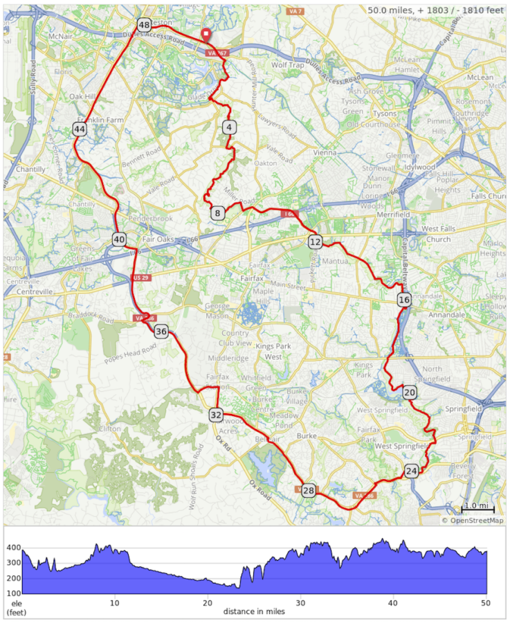
The three routes below were designed to inspire you during your 50, 100, and 150 mile challenges! Challenge participants will see their progress against these route as they log their miles...pretty cool right?!?! The map image links to the respective GPS files for the route. You are welcome to run portions of these routes, but please abide by all county, park, and trail rules. All the routes are entirely within Fairfax County and start in Reston, VA on the W&OD trail. The 50 mile route starts at the intersection of the W&OD and Michael Faraday Drive, while the 100 and 150 mile routes start at the intersection of the W&OD and CCT (Cross County Trail). This intersection is about a half mile west of where the W&OD crosses Hunter Mill Road. The routes use the best trails in Fairfax County and pass through every park where we had Backyard Burns scheduled in 2020 and many more!
50 Mile Inspirational Route
The 50 mile route starts at the intersection of the W&OD and Michael Faraday Drive in Reston, VA and has a total elevation change of over 1,800 feet. The route is about half trail and half pavement as it includes large stretches of both the Cross County Trail (CCT) and the paved path along the Fairfax County Parkway. 50 mile challenge participants will see their progress against this route as they log their miles.
100 Mile Inspirational Route
The 100 mile route starts at the intersection of the W&OD and CCT (Cross County Trail) in Reston, VA and has a total elevation change of over 4,600 feet. This intersection is about a half mile west of where the W&OD crosses Hunter Mill Road. 100 mile challenge participants will see their progress against this route as they log their miles. This route includes large portions of the CCT and the paved path along the Fairfax County Parkway; the full Bull-Run Occoquan Trail (BROT) including sections in Fountainhead, Hemlock, and Bull Run Park; Laurel Hill; Lake Fairfax; and many of the smaller stream valley trails that traverse the county. It's pretty darn awesome.
150 Mile Inspirational Route
The 150 mile route starts at the intersection of the W&OD and CCT (Cross County Trail) in Reston, VA and has a total elevation change of over 7,500 feet. This intersection is about a half mile west of where the W&OD crosses Hunter Mill Road. 150 mile challenge participants will see their progress against this route as they log their miles. This route includes large portions of the CCT and the paved path along the Fairfax County Parkway; the full Bull-Run Occoquan Trail (BROT) including sections in Fountainhead, Hemlock, and Bull Run Park; Lake Fairfax; a major section of the Potomac Heritage Trail in the northern part of the county; Riverbend; Great Falls; Pohick Bay; Meadowood; and many of the smaller stream valley trails that traverse the county. It's a complete monster!
Referral Rewards
Refer your friends and family using your referral link and earn the following rewards:
- Refer 5 people and receive a $25 refund!
- Refer 10 people and receive a $25 refund and our Run More Trails T-shirt in your choice of color!

Challenge Contact Info
If you have any questions about this Challenge, click the button below.
Challenge Survey
Please complete the following survey to help us better understand your challenge experience.


