Lunch Bench Lollipop - 35k+
This is a very challenging course, with over 5300’ of total ascent (4400’ of ascent in the first 14 miles), open to runners only. Please see the Whisler Wilson Overlook – 12k Out-and-Back if you are interested in a course to hike. Please see the Williams Canyon – 25k Out-and-Back if you would like a gentler, but still challenging, course to run.
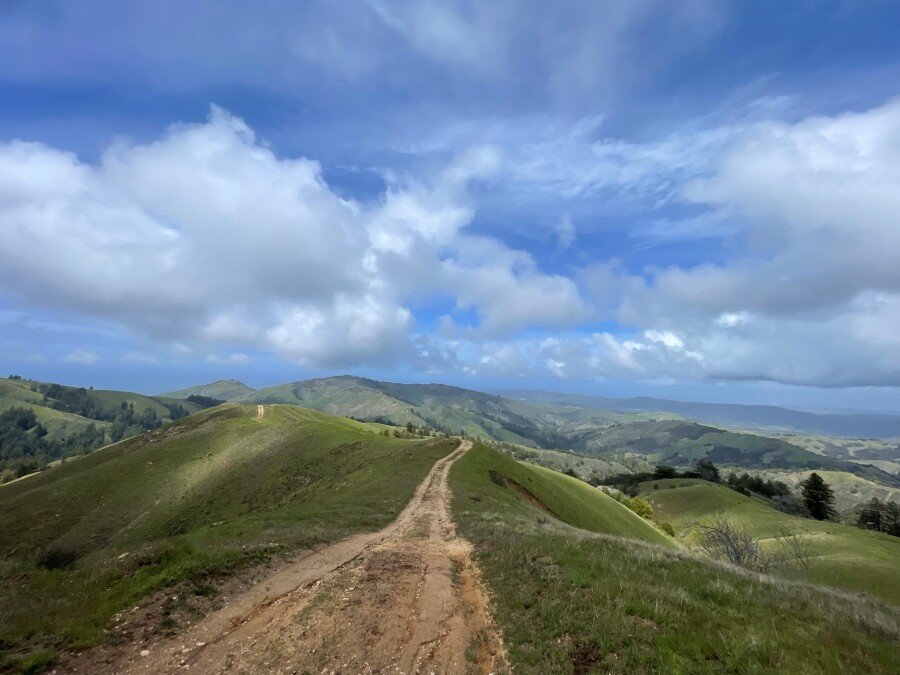
This lollipop course is a serene tour through the backcountry of Palo Corona Regional Park and along a sweeping arc around Big Sur Land Trust’s Mitteldorf Preserve. Runners will enjoy a section of Southbank Trail before starting the climb that will take them past Inspiration Point and Animus Pond to Whisler Wilson Overlook. At Whisler Wilson Overlook they will be rewarded for their efforts by stunning panoramic views of Point Lobos, Carmel River Beach, and the Monterey Peninsula. Runners will then descend to their first creek crossing (San Jose Creek, followed quickly by Seneca Creek) and continue under redwood canopy along fern-lined Seneca Creek, to the beautiful Corona Cabin meadow. From there, it is a little over mile (and a few more creek crossings: Seneca Creek and then San Jose Creek again) to the aid station at Williams Canyon, gateway to Big Sur Land Trust’s Mitteldorf Preserve.
Leaving the Williams Canyon aid station, runners will enjoy a gentle ascent up Wiliams Canyon, running alongside Williams Canyon Creek and passing over the creek via nine of MItteldorf Preserve’s ten historical logging bridges. Instead of crossing the tenth and final bridge, runners will instead begin the climb out of Williams Canyon, winding up to and along Williams Canyon’s rolling rim – hopefully turning looking around often to enjoy sweeping views of Williams Canyon and Carmel Valley. Runners will not quite complete the full tour of the rim, as they turn into Palo Corona Regional Park and make the ascent up to the Lunch Bench, with its incredible views of Monterey Bay, the Pacific Ocean, Carmel Valley, and beyond. With a lot of hard work behind you – 4400’ of ascent 14 miles – we invite runners to enjoy the view as they refuel at the Lunch Bench Aid Station.
After refueling and rehydrating at Lunch Bench, runners will descend along a rolling ridgeline, continuing to enjoy dramatic 365-degree views. A final descent off the ridge takes runners back to the Corona Cabin area; from there, they will continue back to Whisler Wilson Overlook and on to the finish.
This course boasts a total ~5,300 feet of elevation gain and includes some steep ascents and descents. These lands are accessible to the public by guided hike only, so this is a unique opportunity to explore these conserved areas.
Participants are encouraged to carry any aid (i.e., water and snacks) they might need while on the course, although hydration and nourishment will be offered at the Whisler Wilson Aid Station, the Williams Canyon Aid Station, Headwaters Hydration Station (no food), the Lunch Bench Aid Station and (on a limited basis) the Start/Finish. Please note that the Race Team may elect to alter the course or limit the participation of individuals should safety concerns arise due to weather or otherwise.
*All courses are subject to route changes. Any changes will be clearly marked by trail flagging.
Palo Corona Regional Park
Palo Corona Regional Park is one of the Central Coast’s most significant undeveloped open spaces. In the largest land conservation project in Monterey County history, Big Sur Land Trust, the State of California, Monterey Peninsula Regional Park District (MPRPD), and The Nature Conservancy partnered to acquire the 10,000-acre Palo Corona Ranch. The acquisition was finalized in 2004. The 10,000-acre ranch was then divided between the California Department of Fish and Wildlife (CDFW) and MPRPD to be protected in perpetuity. MPRPD created the new Palo Corona Regional Park with the northern 4,350 acres of the former ranch. In 2018, in partnership with The Trust for Public Land, California Wildlife Conservation Board, CDFW, California State Coastal Conservancy, California Natural Resources Agency and Santa Lucia Conservancy, an additional 190 acres of the former Rancho Cañada Golf Course was added to the park.
Beginning at near sea level and rising to over 3,400 feet in elevation, Palo Corona is home to over 500 species of plants as well as several federally-endangered and threatened species including steelhead trout, California red-legged frog, California tiger salamander, Smith’s blue butterfly, golden eagle, and California condor. Palo Corona also provides habitat connectivity for several previously-protected conservation properties, including Garrapata State Park, Joshua Creek Ecological Preserve, Mitteldorf Preserve, Glen Deven Ranch, Point Lobos State Natural Reserve, Santa Lucia Conservancy lands, and the Ventana Wilderness.
Southbank Trail
Big Sur Land Trust acquired land and multiple trail easements in Carmel Valley to create the Southbank Trail starting in 2011. This 1.5-mile long pedestrian and bicycle path is located on the south side of the Carmel River between Quail Lodge and Palo Corona Regional Park. Big Sur Land Trust still owns the land and holds the trail easements. The trail is maintained by the Monterey Peninsula Regional Park District.
Whisler-Wilson Ranch
The property known formerly as the Whisler-Wilson Ranch is a 317-acre parcel that belonged to descendants of the A.M. Allan family. Mr. Allan is credited with originally saving Point Lobos from development in the late 1800s. It is located south of Carmel and inland of Highway One, across from Monastery Beach and Point Lobos State Natural Reserve. Big Sur Land Trust acquired the property from the Whisler and Wilson Family Trusts in 2010 and transferred the entire property to the Monterey Peninsula Regional Park District in 2015 as an addition to Palo Corona Regional Park. The property offers stunning “top of the world” views of Point Lobos State Natural Reserve, Carmel River State Beach, and the Monterey Bay National Marine Sanctuary as well as inland views of Palo Corona Regional Park, Jacks Peak, Carmel Valley and the mountain ranges beyond.
Mitteldorf Preserve
Located in the Santa Lucia Mountains southeast of Carmel and home to Monterey County’s largest and oldest known redwood tree, this amazing landscape was forever protected from industrial logging when Harriet and Arthur Mitteldorf provided funds for Big Sur Land Trust to purchase the property in 1990. Over 1,000 acres of riparian habitat, redwood forest, oak woodlands, chaparral, grasslands, and a rare stand of madrone contribute to the beauty of this important watershed and habitat for several protected species. Additionally, this property serves as an emergency access corridor for the adjacent neighbors. Featuring historic structures, this property is one of our six key preserves, where we offer managed public access through hikes, events, and outdoor youth programming.
Big Sur Land Trust conserves and cares for the lands you love throughout Monterey County.
Big Sur Land Trust’s conserved properties include diverse habitats that span rare sensitive dunes in Marina, majestic redwood forests in the Santa Lucia Mountains and in Big Sur, expansive oak woodlands, grasslands, and river corridors form Arroyo Seco to the Gabilan Mountains. And in 2017, we added our first urban site at Carr Lake in Salinas! Curious to learn more? Click here for a visual tour of Big Sur Land Trust's protected lands throughout Monterey County.
Course Map

Below is a georeferenced and printable PDF version of this course map. If you use the Avenza app on your phone, you can upload this map to display your GPS location on the course.
Click the icon below to download the attached PDF.